|
With
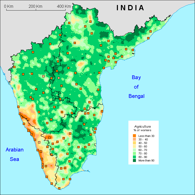
58% of the working population employed in agriculture in 2001,
India remains demographically based on this sector. This fact
is confirmed by this map dominated by zones with more than 80%
of agriculturists. Kerala appears as an exception in South India
as well as in the rest of India. It is all the more remarkable
since this State is less urbanised than the national average
(26% of urban population in 2001). True, the latter figure is
difficult to evaluate since in Kerala it is difficult to clearly
distinguish the limits between urban and rural areas. Nevertheless
this small percentage of agriculturists proves a high level
of economic diversification in the Kerala countryside.
This off-farm diversification goes beyond the borders of the
State, in particular towards Dakshin Kannad (Karnataka) and
the Nilgiris (Tamil Nadu). Historical borders are not always
visible. However, the old borders of the Mysore kingdom, which
would form the core of the present Karnataka, can be seen through
their very agricultural aspect which makes the region different
from the South-West of Karnataka, formely outside Mysore. Natural
borders are clearly to be seen: they correspond to the inner
side of the Ghats and to the limit of areas with heavy rainfall.
This is a paradox since a high ratio of agriculturists could
have been expected due to the relative productivity of local
agriculture. This is to be explained by the extension of the
" Kerala model " from the littoral to the whole Ghats. Generally
speaking, the shores are places of low "agriculturality" indeed,
because of urbanisation and opened up economy. It is very clear
on coastal Andhra, and even more on the littoral of Karnataka,
which is "jammed" between the Kerala pattern and the influence
of Goa, even of Mumbai.
Let us conclude with the role of towns and cities. It is no
surprise that they are associated with a low rate of agriculturists.
There are some exceptions however. The central Karnataka remains
very agricultural even close to Dharwad or Shimoga, whereas
on the contrary, in central or northern Andhra Pradesh (Telangana),
agriculturists are less than 50% in spite of the lack of big
cities.
F.L.
|