|
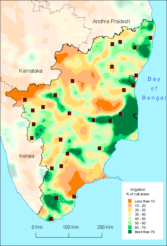
The
densely irrigated zones are found roughly speaking along the
principal rivers of Tamil Nadu, that is to say from North to
South : Palar, Ponniyar, Cauvery and its affluent the Bhavani,
Vaigai and Tambraparni. On each of them, dams have been built
and explain the green spots along these rivers.
The
delta of Cauvery is very famous for its rice production and
for the Grand Anicut (a water diversion structure) built in
the 2nd century, but the name of the river itself is now associated
with political problems related to water. Indeed, the river
takes its source in Karnataka, where several dams control its
flow and its affluents (the Mettur dam located in Tamil Nadu
also regulates the flow). Tamil Nadu has then to regularly request
that Karnataka releases more water downstream to satisfy the
needs of the farmers in the delta region.
Besides
these very irrigated zones located along rivers and corresponding
to intensive zones of rice growing [see the comment of the map
of Andhra Pradesh ], it is difficult - as for Andhra Pradesh
- to explain the geographical distribution of irrigation in
Tamil Nadu simply by topography or hydrography. If the tanks
for example are located in all the eastern part of the state,
their density can be different as the green spot in the South
of Tambraparni is only due to tanks. In the same way, some zones
with 40 to 60% of irrigation can be the result of the use of
various techniques, for example tanks and tubewells. The diversity
of irrigation types with their own characteristics (dependance
on rainfall and runoff for rainfed tank, type of soil and depth
of the watertable for access to ground water, etc.) makes it
difficult to characterize the variable percentage of irrigated
lands.
O.A.
|