|
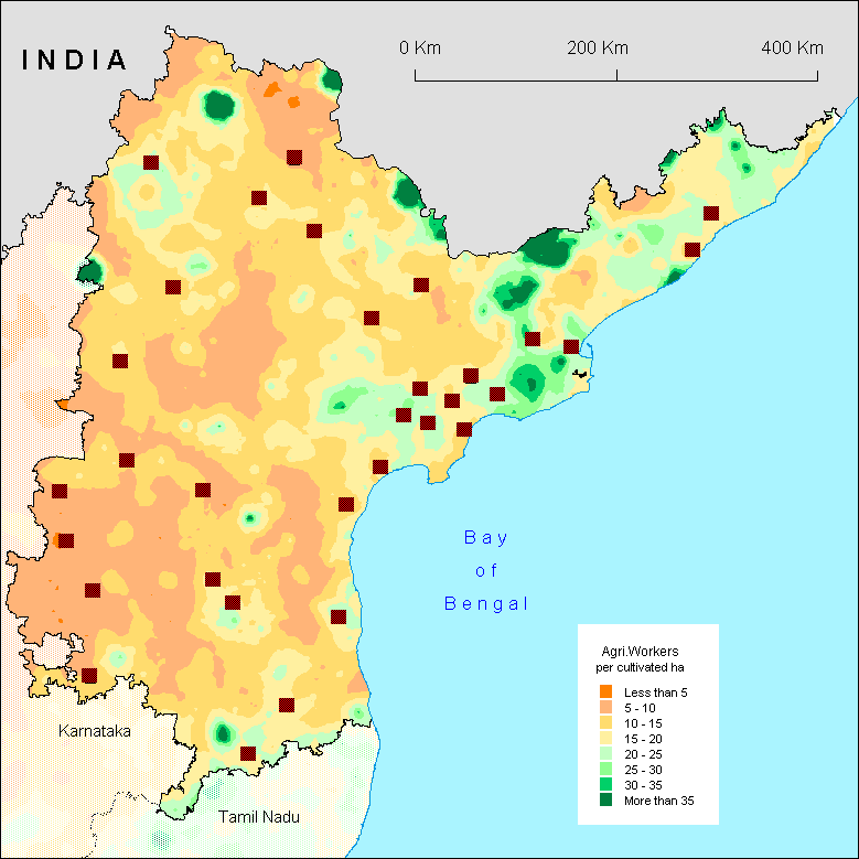
Like on the other maps of Andhra Pradesh, no clear distinction can be made between the three traditional regions of the State. However, Rayalaseema can be considered as a region with a low density of agriculturists per hectare, while coastal Andhra has a high density and Telangana stays in between.
Of course the irrigation factor plays an important role. The Godaveri delta is clearly noticeable, as well as the upper delta of Krishna, Nizam Sagar or to a lesser extent Nagarjuna sagar. On the contrary, the rainfed Rayalaseema has a low density of agriculturists, since the low productivity of land can not allow the survival of many farmers. Cuddapah district looks fortunate in this matter since the density of agricultural workers is medium while the map of irrigation shows a high level of irrigation (or irrigation is not very efficient there?). On the contrary the north of East Godaveri district looks unfortunate since the density is high whereas there is hardly any irrigation (or are there tubewells?). Anyway irrigation cannot explain the whole map. Green patches on the borders (e.g. in forested Adilabad district) need some other explanation.
The level of economic diversification has also
to be taken in account, since it relieves the demographic pressure
on land resource. This is no surprise that generally cities
create low density halos - except in Rayalaseema where the urban
power for economic diversification in (peri)urban areas looks
very poor.
F.L.
|