|
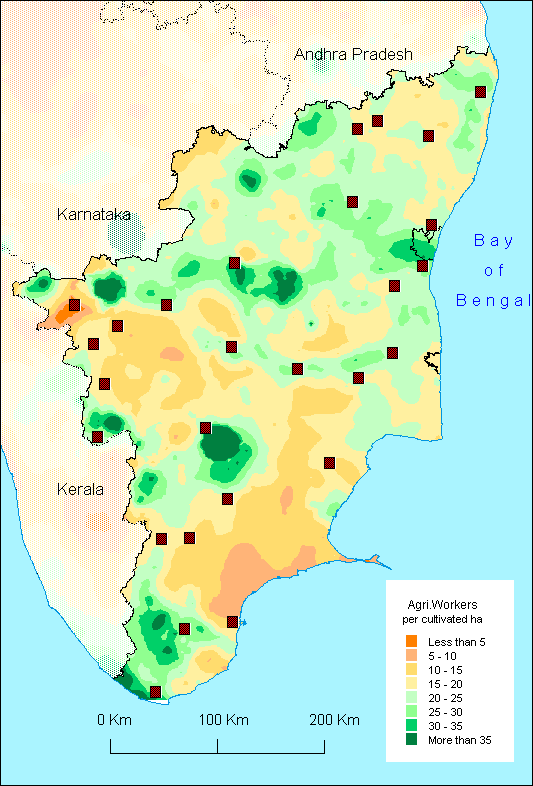
This
map shows an important contrast between a central triangle with
a low density of agricultural workers, from Coonoor to Tuticorin,
and the rest of Tamil Nadu. Even this triangle has an important
exception in its middle, namely the Madurai region. Such discrepancies
are partly explained by irrigation, which enables a large number
of agriculturists per hectare thanks to higher yields per crop
and per year. Hence the course of the Kaveri river is spectacularly
visible. Note however that its delta is only light green whereas
higher densities could have been expected. This proves that
agricultural productivity in the delta is no very high, unlike
Pondicherry area or in the South the Tamprabarani basin (Tirunelveli).
On the other hand, dry areas near Erode or Tuticorin district
have less than 0.5 agriculturist per cultivated hectare.
Other explanations are necessary, however, in order to explain all the situations. The Madurai-Dindigul region, for instance, has high densities thanks not only to irrigation, also to part-time non agricultural income which enables many farmers to survive in spite of limited agricultural scopes. Urban influences and diversified economies are important factors indeed: see the Western Nilgiris where a high level of urbanisation, tourism (Ooty), army-induced activities, the humid climate as well the relatively low ratio of cultivated area may explain the high density of agricultural workers. The contrast with the neighbouring Coonoor area is striking (and difficult to explain since according to the map of the percentage of workers in agriculture the whole Nilgiris district, including Coonoor area, has a high level of economic diversification). Similarly, rather high densities in the east of Dharmapuri district are possibly due to the positive influence of Krishnagiri (see maps of industry and service) and some irrigation: it contrasts with the Western part of the district, unirrigated and remote (in spite of the nearness of Bangalore) because of the Melagiri hills.
F.L.
|