|
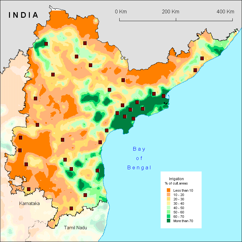
Zones
with more than 40% of irrigation are located in the plain (see
the physical map [www.mapsofindia.com/maps/andhrapradesh/andhrapradeshphysical.htm]),
except for the north of Andhra Pradesh where the irrigated lands
benefit from dams on the Godavari and its affluents.
In
the plain however, the density of the irrigated lands is not
homogeneous and cannot be explained by a simple physical determinism
of topography or hydrography as we had advanced it on the scale
of South India. Sure, deltas are densely irrigated. But, the
Nagarjuna Sagar dam and its long canals explain that the irrigated
lands do not follow strictly the Krishna valley. Near Cudappah,
the geographical distribution of irrigation is complex to interpret.
It is first of all astonishing to see the influence of Kurnool
Cuddappah Canal only close to Cudappah. Then, although small
dams exist on the affluents of the Penner, the green spots result
more from an irrigation by pumps or tank, in this landscape
of valleys steepsided within Nallamalai and Velikonda hills
surrounding Cuddappah from North to South. Other factors - such
as a more or less easy access to the ground water, or undoubtedly
also social and socio-economic factors which remain to be determined
- may intervene to understand this geography of irrigation.
It
is interesting to compare this map of irrigation with that of
the percentage of cultivators [cultivators % of agriculture
workforce]: the areas with great density of irrigation suit
the zones where the cultivators are proportionally very few,
whereas the number of workers is important [agricultural workers
per cultivated hectares]. They represent in fact the zones of
intensive rice growing, activity which requires many workers
and which, here, depends on labour employed by the cultivators.
The same phenomenon can be observed in Tamil Nadu.
O.A.
|