|
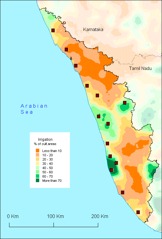
This
map could make believe that the relief is an essential explanatory
factor of the geographical repartition of irrigation, because
of the hill range of the Western Ghats located at the east of
the State where zones with less irrigation are found. However,
the two maps are not superimposed (cf the relief map on the
site [www.mapsofindia.com/maps/kerala/keralaphysical.htm]).
One sees on the contrary well irrigated zones in the mountains,
in particular the Mullaperiyar dam, the water of which is used
by Tamil Nadu in spite of the protest of Kerala. In the same
way, all the low land is not irrigated, for several reasons:
certain places require more drainage than irrigation because
of the heavy rains; the use of water can also be restricted
on coastal strip by the problems of salinity. In Palghat pass,
where there is less rain, irrigation is more important as one
could expect, benefitting also from some dams.
A
diversity of irrigation techniques is used in Kerala (tank,
pound, well, channel, diversion), but one of it is specific
and localised in the North of the State: it is called surangam
and consists in a horizontal drilling carried out in a mountain
foothill until reaching the ground water, such as the famous
qanat of the Middle East. The tunnel thus dug can measure up
to 300 meters length.
O.A.
|