|
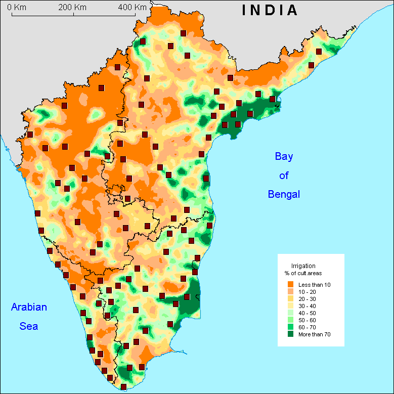
The
geographical distribution of the irrigation appears definitely
unequal. The availability of surface water is, in a first approximation,
the main factor explaining this geography : first of all, irrigation
is less important on the dry inland Deccan or in the moutainous
areas of the Ghats - naturally very well watered- that in the
plains of Tamil Nadu and Andhra Pradesh. Second, high percentage
of irrigated lands is located preferentially along big rivers
and in their deltas (that of Cauvery and Godavari take shape
clearly). Then runoff water and rivers appear crucial for irrigation,
as they feed the canals, supply the tanks [cf. definition in
the legend of the Karnataka map] and fill the large dams..
On
the whole, it is remarkable to note that most of the densely
irrigated zones result from major engineering works such as
digging of hundreds kilometers long canals, improvement of water
diversion structure (anicut) and building of large dams. The
Nagarjunasagar project on the Krishna river in Andhra Pradesh,
started in 1956 and planned to provide water to 830 000 hectares,
the Pochampad project on the Godavari river in North of Andhra
Pradesh and the Tungabahdra project in Karnataka that provides
water to 350 000 hectares are among the biggest irrigation projects.
As a result of this development, canal irrigation has now become
the first source of irrigation in South India (39% of irrigated
lands) although it was introduced on a large scale during the
last 150 years only. It is followed by the use of the subsurface
water (30%) which increased a lot since the years 1960, because
of the political efforts of the Green Revolution to develop
it and to electrify the countryside.
The
percentage of irrigated lands does not systematically predict
cultures grown, because of the diversity of types of irrigation.
However in the zones with great density of irrigation, rice
or sugarcane are preferentially grown, while in the drier zones
dominate less consuming water plants, such as sorghum, eleusine
(a kind of millet), etc.
The
data of the 1991 census do not inform us either about the intensity
of the irrigation, i.e. the number of irrigated cultures per
year, knowing for example that an irrigation by tubewell makes
it more possible to get rid of the climatic constraints than
an irrigation by tank.
O.A.
|