|
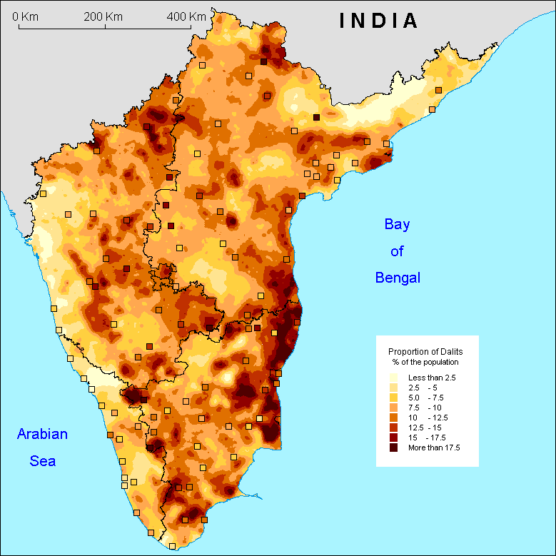
The map of the percentage of Dalits (that is, more precisely, those classified SC by the government) shows a very uneven overall pattern with local concentrations and zones of lower densities. This is due to an interplay of many different factors and it is certainly quite impossible to offer a single simple and valid explanation for this distribution. The state by state commentaries will be able to give more reliable explanations. However, it is nonetheless possible, at the present scale, to outline larger regions of unequal distribution of these populations:
The
zones of concentration: the first striking feature are the
higher concentrations of Dalits in Tamil Nadu, especially along
the Coromandel coast and across the border into to Andhra Pradesh.
The SC castes present there are well known as their caste name,
Parayar, has come to encompass, through its English spelling,
the very notion of social exclusion: pariah. High concentration
of dalits are also found in the western half of Karnataka.
The
'empty' zones: In the tribal areas, the distribution
of dalits is very low. This is explained by the fact that the
tribal areas are almost exclusively inhabited by the tribals
themselves (see map of tribals for
comparison) and very few 'non-tribal' disrupt this overall pattern.
Then there is the western coast, running from Kerala right up
to the northern Karnataka coastline for which we might hypothesise
that the early commercial exchanges with the outside might have
affected the caste system. There is another argument to explain
this pattern which is that of conversion. In effect, in Kerala,
the Muslims and Christians are numerous but the government only
includes Hindus (and recently converted SC) in its definition
of SCs.
S.O.
|