|
Andhra Pradesh is a land of disparity. At the state level, the most fertile deltas meet some of the driest regions, the forested areas are still inhabited by hunters and gatherers and where shifting cultivation is still practiced. This contrast is to be found again at the local level where towns seemingly ignore the rural world surrounding them.
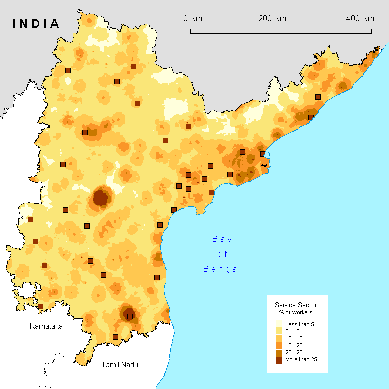
The distribution of tertiary workers does not escape this disparity. The deltas have gone through an urban and economic development followed by an important proportion of tertiary workers. Hyderabad, a powerless metropole, did not manage to influence its hinterland in the manner Chennai and Bangalore did. However, this map highlights the importance of the two main religious centres of Andhra Pradesh: Tirupati in the south and Srisailam in the centre. The former is part of an urban and industrial network which includes Chittoor and is linked to the Palar valley in Tamil Nadu. The latter plays a leading role unknown to other more important cities, even if the cartographic smoothing tends to exaggerate this phenomenon.
It is surprising to notice how the towns are isolated from their surrounding rural areas as opposed to what is to be found on the maps of the other southern states, especially Tamil Nadu. The numerous pockets where the tertiary rate is at its minimum follow the pattern of lesser development and lower densities, such as the northern border of Andhra Pradesh, a mountainous region difficult to access. In the region, the map of services is similar to that of the industry. Generally, however, it is the whole northern portion of the map, apart from the coast, which is under equipped in services.
S.O.
|