|
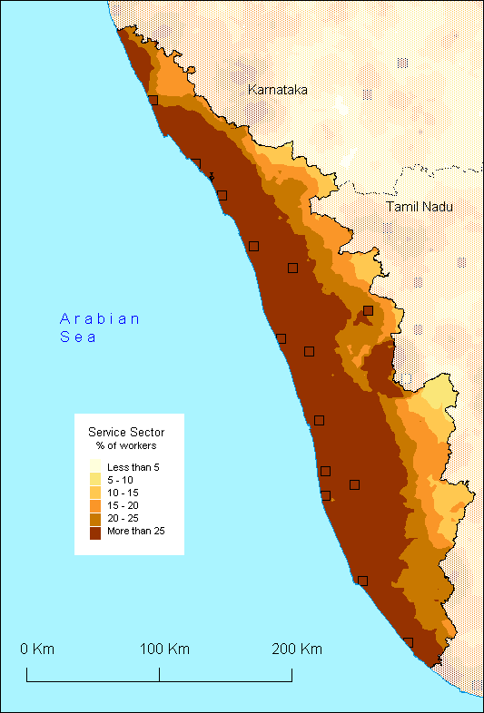
At the national level, the state of Kerala stands out by its high number of tertiary workers (number). This reflects the level of development in the state, which is also noticeable in maps such as that of alphabetisation and, to a lesser degree, that of the industry. Within the state, the pattern seems to be relatively homogeneous. In effect, the distribution of the workers forms parallel stretches to the coast line, its density obviously diminishing when approching the Ghats (that is, from the lowlands to the highlands). The second major feature standing out from this map is the way in which the nature of the landscape correlates with the availability of services. The shapes of the landscape are indirectly highlighted by the increase of service available in the major hill passes such as Shencottah in the South as well as the major thoroughfare that goes through Kumily. What is even more clearly noticeable is the virtual lack of services at the hilltops of the Ghats.
The
final important feature in this map is the absence of the 'concentric
ring-pattern' organisation which is common all over the rest
of South India. If this distribution is partially explained
by the classification of the data (Kerala has the highest value,
which saturates the last class), this situation is better understood
by referring to the overall mode of population distribution
found in Kerala. In effect, the whole coastline is characterised
by very high densities (more than 1000 inhabitants per square
kilometre) and a level of development equivalent to that of
the urban zones of other states. This maps gives the overall
impression that Kerala is one long town spread over 600 km.
Furthermore, scattered settlement pattern, which characterises
this region, encourage the spread of services throughout the
whole state.
S.O.
|