|
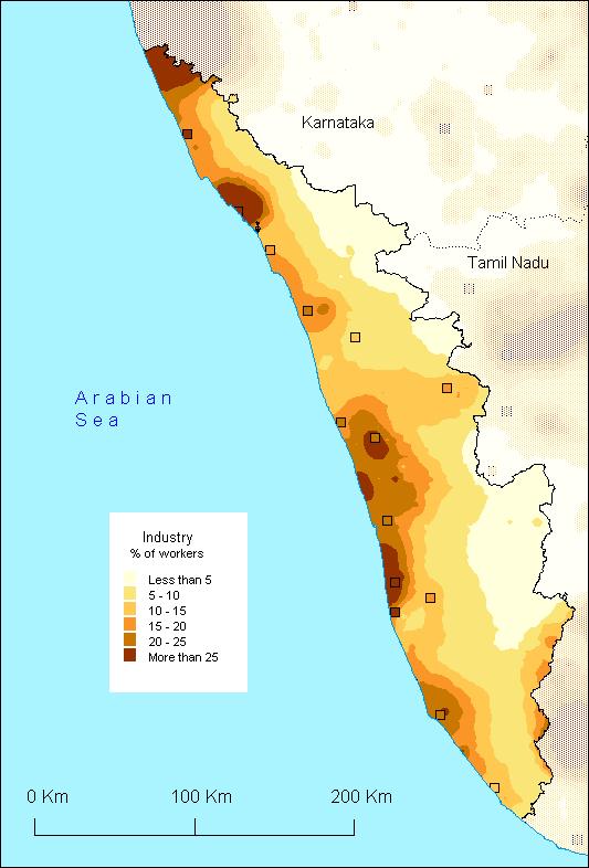
Kerala
does not have the reputation of being a highly industrialised
state... and yet the map of the distribution of the workers
of the secondary sector definitly brings out the fact that if
Kerala does not stand out on the national scale for any specific
industrial specialisation, it nonetheless appears clearly marked
by the industrial sector in general.
The geography of the malayali keralite follows a well set pattern: it is more important along the coast and concentrates around certain cities such as Kollam in the south and more importantly around Allapuzha-Shertallai, Thrissur and Kannur. In the far north, the industrial influence of Mangalore spills over the Karnataka border into Kasaragod district. Moving inland and upward into the Ghats, the industrialisation level gradually diminishes, except for the Palakkad region which clearly makes a transition towards the important industrial region of Coimbatore in Tamil Nadu.
If there is no specific industrial specialisation in Kerala, there is an original and typical activity: the industry of Coir. Allapuzha is considered the nerve centre of this industry which is also present in other industrial centres. Cottage Industries are also fairly widespread as are the sectors of handloom weaving and beedi making.
In
conclusion, the map shows an interesting aspect of Kerala where
industry, as well as services, (see the map of the service
sector) are well developed and well distributed, exception
made for the Ghats which constitute an overwhelming physical
boundary disrupting an otherwise harmonious distribution.
S.O.
|